Plan D

In “From The Ground Up” I described how I was overwhelmed by the daunting journey that I had embarked upon when I announced that I would learn to fly. The story introduced the fact that I needed strategies to overcome the obstacles and described the first strategy: Make a plan, work the plan, and work it hard! Repeat.
A previous story, “A Tale of Two First Solos” described two tactics that I used to master the art of landing the airplane: Research and Networking.
The strategy in this story is Improvise, or in other words, Make a plan, work the plan, change the plan. Repeat!, using my long solo cross country as the example.
In order to obtain a pilot license, a student must fly cross country for 5 hours (meaning taking off and landing at multiple airports, alone). To accomplish this, the candidate normally conducts two solo cross country flights: a 2-hour flight and a 3-hour flight. I had already conducted my short cross country flight – from Oshawa to Lindsay to Peterborough and back to Oshawa, with no problems.
Of course, then the weather got in the way and it was another several weeks before I was able to conduct the long one. In the meantime, the Oshawa Airport had closed for runway construction, so we had relocated the airplane to the Greenbank Airport, a grass strip airport about 12 NM north of Oshawa. I had never flown off or onto grass, so my instructor took me up for a few circuits the day before I was to fly the cross country flight.
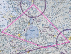
I woke up early on the morning of the flight and got all the latest weather information that I needed to plan the flight. The key piece of information that I needed was the forecasted direction and speed of the winds at the airports that I would be flying to and at the various altitudes along my route of flight. Using the flight computer, I calculated the compass headings that I would use for each of the four legs: Greenbank to Collingwood to Muskoka to Peterborough to Greenbank.
Now… it’s pretty hard to get lost flying in Southern Ontario. Almost as soon as you are airborne, you can see Lake Ontario to the south and the CN Tower in downtown Toronto. By the time you are at circuit altitude, you can see Lake Simcoe to the north-west. And there are lots of other recognizable lakes and cities and towns. I was not worried about getting lost. I had all my compass headings figured out and I had flown to all of these airports before, except Greenbank.
Plan A was to fly the compass heading. Also, I had a map, with the route marked in pink, open on my lap, so I could check along the way to make sure I was on course. Sure enough, my planned compass heading had me pointed to halfway up Cook’s Bay at the south end of Lake Simcoe. From there, I just stayed on the same heading and landed at Collingwood. After taking off from Collingwood, though, my next planned compass heading wasn’t working quite as well. The line on my map was drawn parallel to and a bit north of the shoreline of Georgian Bay, but as I flew using my planned compass heading I found myself a lot north of the shoreline. Time for Plan B.
Plan B was simply to fly the route using the map. I flew along the south shore of Georgian Bay and, after leaving the shoreline behind me, I used highways, railroad tracks, power lines, towns and other lakes, to stay on my track. That worked perfectly. Also, the Muskoka airport is easy to find as it’s just north of a fairly large town and the runway is very long.
As I approached the area, I listened on the Muskoka radio frequency to get ready to work myself in with the other traffic and discovered that the runway that was being used for take-off and landing was opposite to the one that I had expected based on the forecasted winds. The winds had shifted and were significantly different from what had been forecasted. Well, that explained why my planned compass heading was no longer working. No problem. I adapted and landed at Muskoka.
I took off from Muskoka and, sure enough, my planned compass heading for that leg was useless. So, I pointed the airplane to the south-east and, using my map, I flew to Peterborough.
So far, the three airports that I had landed at were airports that I had flown to before. Also, they had paved runways, so they are clearly visible from 10 miles away.
Neither was the case with Greenbank. I had never flown to the Greenbank Airport, I had only done circuits there. Also, the runway is a grass strip, a green grass strip, in a green field, surrounded by other green fields. I knew, from talking to other pilots, that I could possibly be almost on top of it and not be able to find it.
Plan C. After taking off from Peterborough, I pointed towards Lake Scugog, which is the lake near the Greenbank airport, turned on my GPS and pressed “Nearest”, then “Airport”. The result it gave me was “Peterborough”. Oops, of course, since I had just left from there, that would be the nearest airport. I waited until I thought I was more than halfway to Greenbank and tried again. “Nearest”, then “Airport”…the result was “Lindsay”, which was a different airport a bit to the north! Darn. Sure enough, I was closer to Lindsay than to Greenbank. A few minutes later, when I was sure that Greenbank was the closest airport, I tried again, but still got Lindsay as the result. Uh, oh, maybe Greenbank is not in the GPS database – it is, after all, a very small airport.
Plan D. By this time, I was approaching Lake Scugog and Greenbank was just on the other side of the lake, about 10 minutes away. I looked at the map for inspiration and I found it on Scugog Island, which is a large island in the middle of Lake Scugog. There are two main roads on Scugog Island – a north/south road and an east/west road.

Both were marked on my map. I noticed that if I drew a straight line along the east/west road and extended that line to the west, it pointed directly to the Greenbank airport. It was like an arrow, saying “this way to Greenbank”.

The road was quite a bit south of my track, so I flew south and as I approached Scugog Island, I found the road and lined myself up with it. I carefully flew straight along the road, to the west side of the island, looked straight ahead and even though I was still 4 miles from the airport, I saw it clearly! Plan D had worked! I flew overhead and joined the right downwind for runway 16, as if I flown there dozens of times!